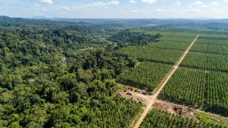

Distinguishing between naturally regenerating ecosystems and agricultural tree crops like oil palm requires analyzing decades of growth cycles rather than a single snapshot in time. This necessity has driven the collaboration between Google DeepMind and the World Resources Institute to develop ForTy, an artificial intelligence framework designed to map global forest typology with unprecedented granularity. Unlike previous satellite datasets that often conflated all green canopies into a single category, ForTy utilizes high-resolution 10-meter imagery to differentiate between primary forests, naturally regenerating habitats, and industrial timber plantations. By establishing a robust baseline for the year 2020, this tool provides the environmental community with a critical instrument for monitoring global land-use transitions. The initiative effectively bridges a long-standing information gap that previously hindered precise ecological assessments across diverse biomes, offering a comprehensive and unified perspective on the current state of global forest health and biodiversity.
Advanced AI Architectures: Refined Modeling Processes
The technological core of the ForTy initiative is the AlphaEarth Foundations model, a sophisticated architecture that functions as a virtual satellite capable of synthesizing vast streams of multi-modal information. This system processes optical imagery, radar data, laser scans, and complex climate simulations to generate compact mathematical descriptions known as embeddings for every 10-meter pixel of the Earth’s surface. These embeddings allow the artificial intelligence to perceive subtle nuances in vegetation structure and land characteristics that are often invisible to the naked human eye or standard classification algorithms. To ensure the reliability of these insights, the development team implemented a rigorous three-stage modeling pipeline that incorporates historical forest loss and tree height metrics. This structural depth enables the model to distinguish between temporary disturbances and permanent land-use changes, thereby maintaining temporal consistency across multiple years of observation while filtering out the noise inherent in massive planetary datasets.
Beyond the foundational architectural models, the project integrated the Gemini language model to facilitate the alignment of diverse training datasets with the complex legal definitions established by international regulatory bodies. This step was crucial for ensuring that the automated classifications met the specific criteria required for environmental compliance and reporting on a global scale. Furthermore, the accuracy of the system was significantly enhanced through multiple rounds of active learning, during which human experts reviewed and corrected approximately 43,000 instances of misclassification. These interventions allowed the model to refine its understanding of geographically specific landscapes, such as accurately identifying the differences between European vineyards and African oil palm plantations. This collaborative approach between human expertise and machine learning not only improved the precision of the final map but also established a higher standard for automated land-use monitoring that accounts for the intricate realities of local agricultural practices and ecological variations.
Global Trade Regulations: Analyzing Land-Use History
A significant motivation for the deployment of the ForTy system is the increasing pressure from international trade regulations, most notably the European Union Regulation on Deforestation-free Products. This policy mandates that commodities traded within the European market must not be linked to land that has undergone deforestation or degradation since the end of 2020. Consequently, businesses and regulatory agencies require a definitive and transparent historical reference point to verify the integrity of global supply chains. ForTy serves this need by providing the necessary 2020 baseline data, allowing stakeholders to distinguish between legitimate timber harvesting and the illegal conversion of primary forests into agricultural land. By categorizing tree crops like cocoa and oil palm as agricultural products rather than natural forest cover, the tool empowers companies to provide evidence of their sustainability claims. This transparency is vital for maintaining market access while simultaneously encouraging responsible land management practices that prioritize the preservation of standing primary forests.
Identifying the specific type of forest cover presents a unique challenge because a mature, managed timber plantation can appear visually identical to a biodiverse natural forest when viewed from space. To overcome this limitation, the ForTy methodology focuses on analyzing long-term growth cycles and distinct planting patterns rather than relying on a single moment of observation. The researchers utilized a 40-year rotation period as a heuristic guide to differentiate industrial operations from naturally occurring forest growth. This longitudinal perspective acknowledges that a forest’s identity is frequently rooted in its management history and intended land use rather than its immediate visual characteristics. While this approach significantly improves classification accuracy, it also requires the system to account for regional differences in how land is utilized and managed by local populations. By tracking the life cycle of trees from planting to harvest, ForTy provides a more nuanced understanding of how human activities interact with natural ecosystems, which is essential for developing effective conservation strategies.
Performance Metrics: Regional Insights and Global Trends
The efficacy of the ForTy system was subjected to rigorous validation by environmental experts who evaluated over 8,000 distinct sites, resulting in a high overall accuracy rate of 90.2 percent. While the model demonstrated exceptional performance in identifying primary forests with an 89 percent accuracy rate, it encountered greater difficulty when classifying more complex land-use categories. Specifically, the system’s ability to correctly identify tree crops and industrial plantations was notably lower, hovering around 50 to 60 percent. These performance variations reflect the inherent difficulty of distinguishing between highly managed landscapes and those that are partially natural. Additionally, the data revealed certain systematic biases, such as a tendency to mislabel forests near roads and human infrastructure as degraded even when the core ecosystem remained intact. These findings underscore the continuous need for human oversight and the refinement of training data to ensure that automated tools do not inadvertently penalize areas based on their proximity to human development.
Analysis of the global tree cover through the ForTy lens has provided a detailed and somewhat sobering look at the distribution of the world’s 4.1 billion hectares of forest. In Northern Europe, specifically within countries like Sweden and Finland, the data indicates that approximately two-thirds of the forest cover consists of planted timber rather than primary natural ecosystems. While these regions maintain high levels of green cover, the lack of primary forest poses significant challenges for biodiversity conservation. In contrast, equatorial regions such as the Amazon basin and the Congo River basin retain the largest shares of primary forest on the planet, yet these areas remain under the most intense pressure from agricultural expansion and land conversion. Furthermore, regional errors in the dataset highlight the complexity of global mapping; the model currently overestimates forest cover in the Russian conifer belts while underestimating it across various African landscapes. These discrepancies often arise from the AI confusing dry savannas and open woodlands with non-forest land.
Strategic Implementation: Future Ecological Governance
To maximize the impact of this technological advancement, Google DeepMind and the World Resources Institute ensured that the ForTy map and its underlying code were released under an open-access license. This strategic decision enabled governments, non-governmental organizations, and the private sector to integrate high-quality environmental data into their respective decision-making processes. By hosting the data on platforms like Google Earth Engine, the initiative provided a shared foundation for international cooperation on climate goals and biodiversity protection. The integration of this tool with other artificial intelligence systems has already begun to enhance the detection of environmental crises, such as prolonged droughts and sudden flood events, creating a more responsive digital nervous system for the planet. Looking forward, the focus shifted toward the inclusion of more granular categories for open woodlands to better align with evolving regulatory standards. This proactive approach established a clear path for future environmental governance, emphasizing the role of transparent data in securing the health of global forest ecosystems.
In the final phase of this project, the researchers successfully integrated the ForTy framework with the Tropical Forest Forever Facility to support more targeted conservation financing models. This move allowed for the direct application of high-resolution data in protecting critical habitats that were previously difficult to monitor with precision. By providing a transparent and objective record of land use, the initiative essentially removed the ambiguity that often surrounded corporate sustainability reporting and national environmental pledges. The development of this tool represented a significant milestone in the shift toward data-driven ecological management, as it empowered local communities and international bodies to hold stakeholders accountable for land-use changes. Ultimately, the successful deployment of these AI-driven maps demonstrated that technological innovation could be effectively harnessed to meet the urgent demands of global forest preservation. This established a new benchmark for how digital tools could serve as pillars for the restoration of the planet’s natural equilibrium.